We realised that it could be hard to keep track of all the pages and links we created on our server and then find them back in the favorites of our browser.
So we created this new light page where you can find everything in one place: all the links and all the pages.
The pages above are almost the same, there is only one difference. The second page – named “Meteo Link” – shows all the links visible as specific web addresses, therefore it is much more easy for everybody to retrieve them.
Fair wind and calm seas.
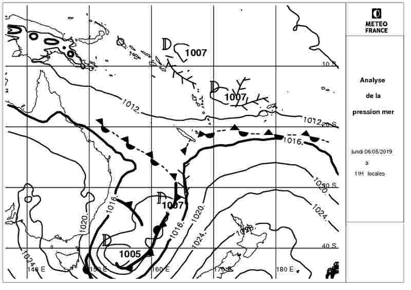
We found two different weather bulletins on the Meteo France New Caledonia website.
The first is good for coastal navigation up to 20nm and it covers entirely New Caledonia, even the Loyalty Islands. The second bullettin is valid for blue water cruising around New Caledonia, between 13S et 25S And between 158E and 172E. It is good for ocean crossing from and to New Zealand and East Australia.
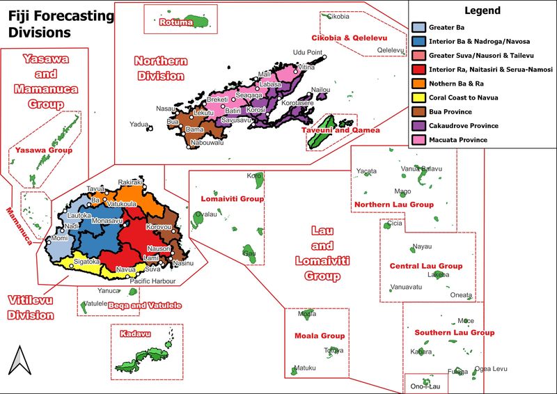
Costal weather bullettin It is available to download from this LINK. It is a small HTML page (9 Kbyte) that you can read with every browser on every system: Windows, Apple, Android, Linux. The weather bullettin describes five regions of New Caledonia that you can see on the image on top. You can download this image from this IMAGELINK (15 Kbyte). This bullettin is released three time a day: 06.30, 11.00 and 15.00 local time (UTC+11).
Blue water (Large) weather bullettin It is available to download from this LINK. It is a small HTML page (4 Kbyte) that you can read with every browser on every system: Windows, Apple, Android, Linux. This bullettin is released two time a day: 02.15 and 14.00 local time (UTC+11).
Why this page?
Because when you are in the
middle of nowhere, sailing in the ocean far away from a fast internet
connection, reduced images size is a good compromise for download the files
with HF radio, Pactor Modem or Satellite Phone connection.
Disclaimer
The contents of the following
links are provided “AS IS”. The
information could contain technical inaccuracies, errors and out-of-date
informations
Disclaimer
The information contained on
www.y2ksail.com website (the “Service”) is for general information
purposes only.
Y2K Sail assumes no
responsibility for errors or omissions in the contents on the Service.
In no event shall Y2K Sail be
liable for any special, direct, indirect, consequential, or incidental damages
or any damages whatsoever, whether in an action of contract, negligence or
other tort, arising out of or in connection with the use of the Service or the
contents of the Service. Y2K Sail reserves the right to make additions,
deletions, or modification to the contents on the Service at any time without
prior notice
Y2K Sail does not warrant that
the website is free of viruses or other harmful components.
External links disclaimer
www.y2ksail.com website may
contain links to external websites and/or pickup information from external websites
that are not provided or maintained by or in any way affiliated with Y2K Sail
Please note that the Y2K Sail
does not guarantee the accuracy, relevance, timeliness, or completeness of any
information on these external websites.
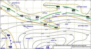
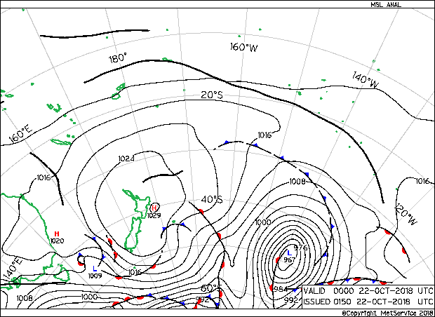
This page contains last analysis chart release from Meteo France.
All these documents are regularly updated by Meteo France at 23.00, 05.00, 11.00 and 17.00 Local time (UTC+11) and they can be downloaded around 03.35, 08.35, 13.35 and 20.35 local time (UTC+11).
So, for example if you need the picture of 11.00 you have to wait the 13.35.
The image (JPG) is cropped to reach a size of 25Kyte.
This image is useful for all the boats that sail between North New Zealand, East Australia up to Coral Sea.
File link:
Latest image-> It contains always last analysis chart available
Why this page?
Because when you are in the
middle of nowhere, sailing in the ocean far away from a fast internet
connection, reduced images size is a good compromise for download the files
with HF radio, Pactor Modem or Satellite Phone connection.
Disclaimer
The contents of the following
links are provided “AS IS”. The
information could contain technical inaccuracies, errors and out-of-date
informations
Disclaimer
The information contained on
www.y2ksail.com website (the “Service”) is for general information
purposes only.
Y2K Sail assumes no
responsibility for errors or omissions in the contents on the Service.
In no event shall Y2K Sail be
liable for any special, direct, indirect, consequential, or incidental damages
or any damages whatsoever, whether in an action of contract, negligence or
other tort, arising out of or in connection with the use of the Service or the
contents of the Service. Y2K Sail reserves the right to make additions,
deletions, or modification to the contents on the Service at any time without
prior notice
Y2K Sail does not warrant that
the website is free of viruses or other harmful components.
External links disclaimer
www.y2ksail.com website may
contain links to external websites and/or pickup information from external websites
that are not provided or maintained by or in any way affiliated with Y2K Sail
Please note that the Y2K Sail
does not guarantee the accuracy, relevance, timeliness, or completeness of any
information on these external websites.
All these documents are
regularly updated from NZ Met Service ‘normally’ every 6 hours, normally at
02.00 – 08.00 – 14.00 – 20-00 UTC TIME
Why this page?
Because when you are in the
middle of nowhere, sailing in the ocean far away from a fast internet
connection, reduce images size is a good compromise for download the files with
HF radio, Pactor Modem or Satellite Phone connection.
Disclaimer
The contents of the following
links are provided “AS IS”. The
information could contain technical inaccuracies, errors and out-of-date
information
File list (all files are
downloaded 5 minutes after every hour):
The information contained on
www.y2ksail.com website (the “Service”) is for general information
purposes only.
Y2K Sail assumes no
responsibility for errors or omissions in the contents on the Service.
In no event shall Y2K Sail be
liable for any special, direct, indirect, consequential, or incidental damages
or any damages whatsoever, whether in an action of contract, negligence or
other tort, arising out of or in connection with the use of the Service or the
contents of the Service. Y2K Sail reserves the right to make additions,
deletions, or modification to the contents on the Service at any time without
prior notice
Y2K Sail does not warrant that
the website is free of viruses or other harmful components.
External links disclaimer
www.y2ksail.com website may
contain links to external websites and/or pickup information from external
websites that are not provided or maintained by or in any way affiliated with
Y2K Sail
Please note that the Y2K Sail
does not guarantee the accuracy, relevance, timeliness, or completeness of any
information on these external websites.
Revision Log
Date
Notes
29th October 2018
Change file format to GIF for a better manage in Airmail software
21st October 2018
Change name of file, now
they are more intelligible
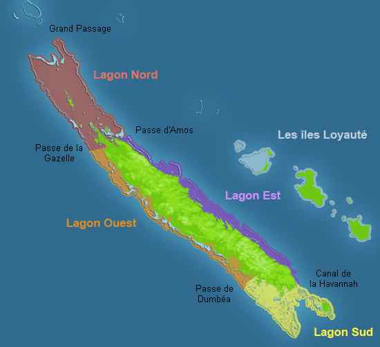
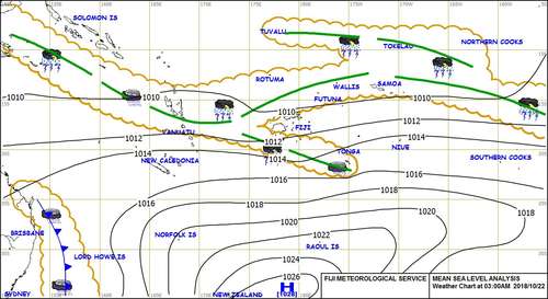
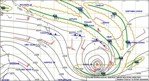
This page contains all WeatherMap coming from Fiji Met Service. Update this page and contents May 5th 2019 due to a new Fiji Met website
All these documents are
regularly updated from Fiji Met Service every 3/4 hours and all images are
cropped and resized to almost 30Kb.
Why? Because when you are in themiddle of nowhere, sailing in the ocean far away from a fast internetconnection, reduce images size is a good compromise for download the files withHF radio, Pactor Modem or Satellite Phone connection.
Because when you are in the middle of nowhere, sailing in the ocean far away from a fast internet connection, reduce images size is a good compromise for download the files with HF radio, Pactor Modem or Satellite Phone connection.
Disclaimer
The contents of the following
links are provided “AS IS”. The
information could contain technical inaccuracies, errors and out-of-date
information
File list (all time are in
Fiji Local Time GMT+12):
The information contained on
www.y2ksail.com website (the “Service”) is for general information
purposes only.
Y2K Sail assumes no
responsibility for errors or omissions in the contents on the Service.
In no event shall Y2K Sail be
liable for any special, direct, indirect, consequential, or incidental damages
or any damages whatsoever, whether in an action of contract, negligence or
other tort, arising out of or in connection with the use of the Service or the
contents of the Service. Y2K Sail reserves the right to make additions,
deletions, or modification to the contents on the Service at any time without
prior notice
Y2K Sail does not warrant that
the website is free of viruses or other harmful components.
External links disclaimer
www.y2ksail.com website may
contain links to external websites and/or pickup information from external
websites that are not provided or maintained by or in any way affiliated with
Y2K Sail
Please note that the Y2K Sail
does not guarantee the accuracy, relevance, timeliness, or completeness of any
information on these external websites.
Welcome to Y2K Sail.
This site is new. Really new.
We start to develop in Tahiti, where we are now, in August 2018.
Why?
Because we need a service online for download some images, from Meteo France, that are too big to download with SSB Radio on board.
So, we develop in a couple of days some routines that download images from some weather sites and after a resize they are ready to download with a low bandwidth device.
I you are interested, leave a comment and as soon as we have an internet connection we will answer for sure.
Manage Cookie Consent
To provide the best experiences, we use technologies like cookies to store and/or access device information. Consenting to these technologies will allow us to process data such as browsing behavior or unique IDs on this site. Not consenting or withdrawing consent, may adversely affect certain features and functions.
Functional
Always active
The technical storage or access is strictly necessary for the legitimate purpose of enabling the use of a specific service explicitly requested by the subscriber or user, or for the sole purpose of carrying out the transmission of a communication over an electronic communications network.
Preferences
The technical storage or access is necessary for the legitimate purpose of storing preferences that are not requested by the subscriber or user.
Statistics
The technical storage or access that is used exclusively for statistical purposes.The technical storage or access that is used exclusively for anonymous statistical purposes. Without a subpoena, voluntary compliance on the part of your Internet Service Provider, or additional records from a third party, information stored or retrieved for this purpose alone cannot usually be used to identify you.
Marketing
The technical storage or access is required to create user profiles to send advertising, or to track the user on a website or across several websites for similar marketing purposes.